| Report Documents
|
|
|
| |
| Map Plotfiles
|
-
No files of this type available
|
| |
| Data Files
|
|
|
| |
| Digital Map Files
|
|
|
| |
| Image Document
|
|
|
| |
| Video Files
|
-
No files of this type available
|
| |
|
All Documents
|
|
|
| Contact
|
|
-
If you have any questions on the information presented, or require additional report data or attachments, please contact the Report Contact
|
|
|
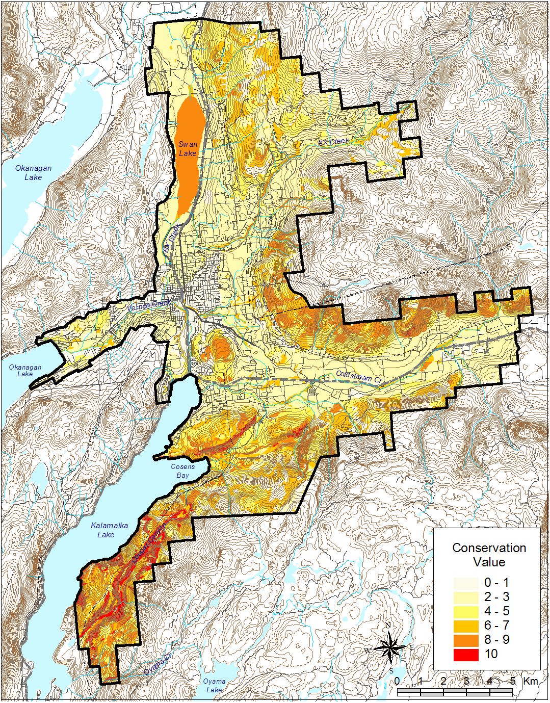
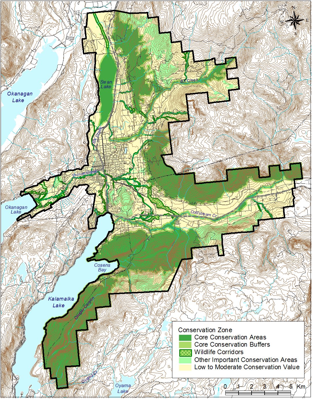
This project includes Terrestrial Ecosystem Mapping with a Sensitive Ecosystems Inventory theme and Wildlife Habitat Assessments for the Coldstream Vernon area of the north Okanagan. The mapping was completed in 2007 at 1:20,000 scale and covers portions of mapsheet numbers 082L014, 082L015, 082L024, 082L025, 082L034, and 082L035. The project follows the Standard for Mapping Terrestrial Ecosystems in BC, 1998 and The Standard for Mapping Ecosystems at Risk, 2006
|
Author: Iverson, K. and P. Uunila
|
Old Reference Number: 4833
|
Old Reference System: BAPID
|
Date Published: Jun 2008
|
Report ID: 15353
|
Audience: Government and Public
|
This project includes Terrestrial Ecosystem Mapping with a Sensitive Ecosystems Inventory and Wildlife Habitat Assessments for the Coldstream Vernon area of the north Okanagan. The mapping was completed in 2007 at 1:20,000 scale and covers portions of mapsheet numbers 082L014, 082L015, 082L024, 082L025, 082L034, and 082L035. Three biogeoclimatic variants are mapped, the IDFdm1, IDFmw1 and IDFxh1. The study falls within three Ecosections, the Northern Okanagan Basin (NOB), the Northern Okanagan Highlands (NOH) and the Shushwap Basin (SHB). Wildlife habitat ratings were developed for the following species: Great Basin Spadefoot, Grasshopper Sparrow, Long-billed Curlew, Swainsons Hawk, Western Screech Owl, Yellow-breasted Chat, Badger, Painted Turtle, Northern Pacific Rattlesnake and Gopher Snake. The project follows the Standard for Mapping Terrestrial Ecosystems in BC, 1998 and The Standard for Mapping Ecosystems at Risk, 2006
|
Report Type
Subject
| |
Amphibians & Reptiles - Gopher snake: Pituophis catenifer |
| |
Amphibians & Reptiles - Northern Pacific Rattlesnake: Crotalus oreganos |
| |
Amphibians & Reptiles - Painted Turtle: Chrysemys picta |
| |
Birds - Grasshopper Sparrow: Ammodramus savannarum |
| |
Birds - Long-billed Curlew: Numenius americanus |
| |
Birds - Swainson's Hawk: Buteo swainsoni |
| |
Birds - Western Screech-Owl: Otus kennicottii |
| |
Birds - Yellow-breasted Chat: Icteria virens |
| |
Biogeoclimatic Zone - IDF Interior Douglas-fir Zone |
| |
Mammals - Badger: Taxidea taxus |
| |
Region - Okanagan |
| |
Terrestrial Information - Terrain Mapping |
| |
Terrestrial Information - Terrestrial Ecosystem Mapping (TEM) |
| |
Terrestrial Information - Wildlife Habitat Ratings (WHR) |
| |
Terrestrial Information - Sensitive Ecosystem Inventory (SEI) |
| |
|
|
