| |
Report: Bella Coola River Floodplain Mapping (including Salloomt and Nusatsum Rivers; Thorsen, Burnt Bridge, and Nooklikonnik Creeks)
| Report Documents
|
|
|
| |
| Map Plotfiles
|
-
No files of this type available
|
| |
| Data Files
|
|
|
| |
| Digital Map Files
|
-
No files of this type available
|
| |
| Image Document
|
- Bella Coola River Floodplain Mapsheet 87-56-1
(pdf/1.8 Mb)
- Bella Coola River Floodplain Mapsheet 87-56-10
(pdf/1.3 Mb)
- Bella Coola River Floodplain Mapsheet 87-56-2
(pdf/1.7 Mb)
- Bella Coola River Floodplain Mapsheet 87-56-3
(pdf/1.8 Mb)
- Bella Coola River Floodplain Mapsheet 87-56-4
(pdf/1.8 Mb)
- Bella Coola River Floodplain Mapsheet 87-56-5
(pdf/1.9 Mb)
- Bella Coola River Floodplain Mapsheet 87-56-6
(pdf/1.2 Mb)
- Bella Coola River Floodplain Mapsheet 87-56-7
(pdf/1.1 Mb)
- Bella Coola River Floodplain Mapsheet 87-56-8
(pdf/1 Mb)
- Bella Coola River Floodplain Mapsheet 87-56-9
(pdf/1.4 Mb)
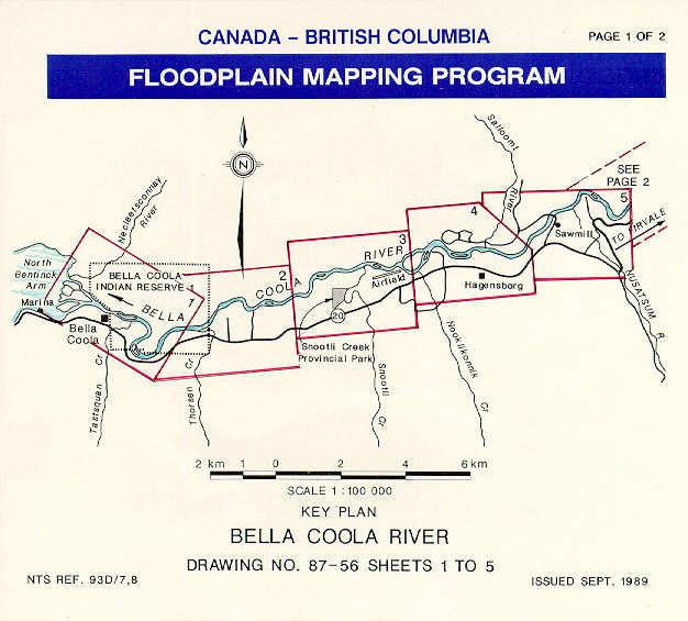
- Bella Coola River Floodplain Mapsheet Key Plan 1 of 2
(jpg/110.2 Kb)
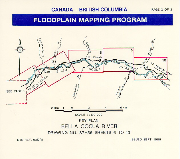
- Bella Coola River Floodplain Mapsheet Key Plan 2 of 2
(gif/99.2 Kb)
- Bridge Sketch (Bella Coola 1981)
(pdf/536.4 Kb)
- Bridge Sketch (Burnt Bridge 1986 )
(pdf/593.6 Kb)
- Bridge Sketch (Nusatsum 1980)
(pdf/2.6 Mb)
- Bridge Sketch (Salloomt 1981)
(pdf/1 Mb)
- Bridge Sketches (Bella Coola 1986 )
(pdf/1.3 Mb)
- Gauging Station 08FB005 Nusatsum River near Hagensborg
Gauge Readings and Gauge Zero
(pdf/346.5 Kb)
- Gauging Station 08FB007 Bella Coola River above Burnt Bridge Creek
Station Description
(pdf/754.6 Kb)
- Thalweg & High Water Mark Profiles (Nusatsum 1980) Dwg 4918-71-27C-4
(pdf/3.6 Mb)
- Thalweg Profile and Detail Soundings near Salloomt Bridge (Bella Coola 1968) Dwg 4596-2-1
(pdf/327 Kb)
- Thalweg, Water Level and Natural Boundary Profiles (Bella Coola 1986) Dwg 87-21-1
(pdf/237.3 Kb)
- Thalweg, Water Level and Natural Boundary Profiles (Bella Coola and Salloomt 1981) Dwg 84-27-12
(pdf/214.1 Kb)
- XS Plan (Bella Coola 1981, 1986; Salloomt 1981; Burnt Bridge 1986) Dwg 84-27-1
(pdf/503.6 Kb)
- XS Plan (Bella Coola 1981, 1986; Salloomt 1981; Burnt Bridge 1986) Dwg 84-27-10
(pdf/658.9 Kb)
- XS Plan (Bella Coola 1981, 1986; Salloomt 1981; Burnt Bridge 1986) Dwg 84-27-11
(pdf/552.8 Kb)
- XS Plan (Bella Coola 1981, 1986; Salloomt 1981; Burnt Bridge 1986) Dwg 84-27-2
(pdf/711.6 Kb)
- XS Plan (Bella Coola 1981, 1986; Salloomt 1981; Burnt Bridge 1986) Dwg 84-27-3
(pdf/727.7 Kb)
- XS Plan (Bella Coola 1981, 1986; Salloomt 1981; Burnt Bridge 1986) Dwg 84-27-4
(pdf/689.2 Kb)
- XS Plan (Bella Coola 1981, 1986; Salloomt 1981; Burnt Bridge 1986) Dwg 84-27-5
(pdf/628.5 Kb)
- XS Plan (Bella Coola 1981, 1986; Salloomt 1981; Burnt Bridge 1986) Dwg 84-27-6
(pdf/647.1 Kb)
- XS Plan (Bella Coola 1981, 1986; Salloomt 1981; Burnt Bridge 1986) Dwg 84-27-7
(pdf/500.6 Kb)
- XS Plan (Bella Coola 1981, 1986; Salloomt 1981; Burnt Bridge 1986) Dwg 84-27-8
(pdf/480.1 Kb)
- XS Plan (Bella Coola 1981, 1986; Salloomt 1981; Burnt Bridge 1986) Dwg 84-27-9
(pdf/497.8 Kb)
- XS Plan (Bella Coola 1968) Dwg 4737-1-5
(pdf/2.3 Mb)
- XS Plan (Bella Coola 1968) Dwg 4737-1-6
(pdf/2.3 Mb)
- XS Plan (Nooklikonnik 1973) Dwg 4737-12-13
(pdf/1.8 Mb)
- XS Plan (Nusatsum 1980)
(txt/316 bytes)
- XS Plan (Nusatsum 1980) Dwg 4918-71-27C-3
(pdf/6.4 Mb)
- XS Plan (Thorsen 1973) Dwg 4737-12-1
(pdf/2 Mb)
- XS Plots (Bella Coola 1968) Dwg 4737-1-21
(pdf/703.1 Kb)
- XS Plots (Bella Coola 1968) Dwg 4737-1-22
(pdf/693.1 Kb)
- XS Plots (Bella Coola 1968) Dwg 4737-1-23
(pdf/651.3 Kb)
- XS Uncontrolled (Blank) Mosaic (Nusatsum 1980) Dwg 5295
(pdf/23.8 Mb)
- XS Uncontrolled Mosaic (Bella Coola 1981, 1986; Salloomt 1981; Burnt Bridge 1986) Dwg A5295-1
(pdf/21 Mb)
- XS Uncontrolled Mosaic (Bella Coola 1981, 1986; Salloomt 1981; Burnt Bridge 1986) Dwg A5295-2
(pdf/22.2 Mb)
- XS Uncontrolled Mosaic (Bella Coola 1981, 1986; Salloomt 1981; Burnt Bridge 1986) Dwg A5295-3
(pdf/21.1 Mb)
- XS and Gauge Water Levels (Bella Coola 1968)
(pdf/2.1 Mb)
- XS and Road Profiles Air Photograph Field Sketch (Nusatsum 1980)
(pdf/1.9 Mb)
|
| |
| Video Files
|
-
No files of this type available
|
| |
|
All Documents
|
|
|
| Contact
|
|
-
If you have any questions on the information presented, or require additional report data or attachments, please contact the Report Contact
|
|
|
Bella Coola River Floodplain Mapping (including Salloomt and Nusatsum Rivers; Thorsen, Burnt Bridge, and Nooklikonnik Creeks) and BC Water Surveys Data
|
Author: BC Water Surveys Unit and Canada-BC Floodplain Mapping Program
|
Old Reference Number: Project #83-101T-0
|
Old Reference System: MoELP Water Surveys and Draughting Section
|
Date Published: Sep 1989
|
Report ID: 1597
|
Audience: Government and Public
|
Designated Floodplain Mapsheets
Design Brief
Channel Survey data including:
Cross section and road profiles, HEC GR data files, Bridge sketches, plans showing location of cross sections
|
Report Type
Subject
| |
Water Information - Floodplain Mapping Program |
| |
|
|
|
|
Warranty Disclaimer
This information is provided as a public service by the Government of British Columbia, Box 9411, Victoria, British Columbia, Canada V8W 9V1.
This Web site and all of the information it contains are provided "as is" without warranty of any kind, whether express or implied. All implied warranties, including, without limitation, implied warranties of merchantability, fitness for a particular purpose, and non-infringement, are hereby expressly disclaimed.
Limitation of Liabilities
Under no circumstances will the Government of British Columbia be liable to any person or business entity for any direct, indirect, special, incidental, consequential, or other damages based on any use of this Web site or any other Web site to which this site is linked, including, without limitation, any lost profits, business interruption, or loss of programs or information, even if the Government of British Columbia has been specifically advised of the possibility of such damages.
|