| |
Report: North Thompson River (Kamloops to Vavenby) Floodplain Mapping (including Barriere and Clearwater Rivers)
| Report Documents
|
|
|
| |
| Map Plotfiles
|
-
No files of this type available
|
| |
| Data Files
|
|
|
| |
| Digital Map Files
|
-
No files of this type available
|
| |
| Image Document
|
- Bridge (CNR North Thompson - Kamloops) Drawing Series 433 (North Thompson)
(zip/583.2 Kb)
- Bridge (Halston Ave Connector) Drawing Series 2810 (North Thompson)
(zip/1.3 Mb)
- Bridge Drawing (North Thompson at Clearwater 1976)
(pdf/318.8 Kb)
- Bridge Drawing Index (Thompson, North and South Thompson at Kamloops)
(pdf/21.8 Kb)
- Bridge Drawings (Barriere 1983)
(pdf/2.1 Mb)
- Bridge Drawings (Clearwater 1979)
(pdf/8.6 Mb)
- Bridge Drawings (North Thompson 1978, 1979)
(pdf/9.9 Mb)
- Gauging Station 08LB047 (North Thompson at Birch Island)
(pdf/1.9 Mb)
- Gauging Station 08LB064 (North Thompson at McLure)
(pdf/1.7 Mb)
- High Water Marks (North Thompson 1986)
(pdf/17.8 Mb)
- High Water Marks (Thompson, North & South Thompson 1997)
(pdf/8.4 Mb)
- Kamloops Area - 1964 Flooding Report (Drawing Series 4412)
(zip/10.7 Mb)
- North Thompson River (Kamloops-McLure) Floodplain Mapsheet A5302-10
(pdf/21.2 Mb)
- North Thompson River (Kamloops-McLure) Floodplain Mapsheet A5302-11
(pdf/18.6 Mb)
- North Thompson River (Kamloops-McLure) Floodplain Mapsheet A5302-12
(pdf/21.6 Mb)
- North Thompson River (Kamloops-McLure) Floodplain Mapsheet A5302-13
(pdf/18.8 Mb)
- North Thompson River (Kamloops-McLure) Floodplain Mapsheet A5302-14
(pdf/19.1 Mb)
- North Thompson River (Kamloops-McLure) Floodplain Mapsheet A5302-15
(pdf/20 Mb)
- North Thompson River (Kamloops-McLure) Floodplain Mapsheet A5302-16
(pdf/20.8 Mb)
- North Thompson River (Kamloops-McLure) Floodplain Mapsheet A5302-17
(pdf/20.8 Mb)
- North Thompson River (Kamloops-McLure) Floodplain Mapsheet A5302-2
(pdf/23.9 Mb)
- North Thompson River (Kamloops-McLure) Floodplain Mapsheet A5302-3
(pdf/21.2 Mb)
- North Thompson River (Kamloops-McLure) Floodplain Mapsheet A5302-4
(pdf/22.3 Mb)
- North Thompson River (Kamloops-McLure) Floodplain Mapsheet A5302-5
(pdf/22.6 Mb)
- North Thompson River (Kamloops-McLure) Floodplain Mapsheet A5302-6
(pdf/21.5 Mb)
- North Thompson River (Kamloops-McLure) Floodplain Mapsheet A5302-7
(pdf/22.6 Mb)
- North Thompson River (Kamloops-McLure) Floodplain Mapsheet A5302-8
(pdf/23.4 Mb)
- North Thompson River (Kamloops-McLure) Floodplain Mapsheet A5302-9
(pdf/24.5 Mb)
- North Thompson River (Little Fort-Vavenby) Floodplain Mapsheet A5302-36
(pdf/23.6 Mb)
- North Thompson River (Little Fort-Vavenby) Floodplain Mapsheet A5302-37
(pdf/24.3 Mb)
- North Thompson River (Little Fort-Vavenby) Floodplain Mapsheet A5302-38
(pdf/26.1 Mb)
- North Thompson River (Little Fort-Vavenby) Floodplain Mapsheet A5302-39
(pdf/25.9 Mb)
- North Thompson River (Little Fort-Vavenby) Floodplain Mapsheet A5302-40
(pdf/26.4 Mb)
- North Thompson River (Little Fort-Vavenby) Floodplain Mapsheet A5302-41
(pdf/26.9 Mb)
- North Thompson River (Little Fort-Vavenby) Floodplain Mapsheet A5302-42
(pdf/24.8 Mb)
- North Thompson River (Little Fort-Vavenby) Floodplain Mapsheet A5302-43
(pdf/24.2 Mb)
- North Thompson River (Little Fort-Vavenby) Floodplain Mapsheet A5302-44
(pdf/25.1 Mb)
- North Thompson River (Little Fort-Vavenby) Floodplain Mapsheet A5302-45
(pdf/26.4 Mb)
- North Thompson River (Little Fort-Vavenby) Floodplain Mapsheet A5302-46
(pdf/31.1 Mb)
- North Thompson River (Little Fort-Vavenby) Floodplain Mapsheet A5302-47
(pdf/27 Mb)
- North Thompson River (Little Fort-Vavenby) Floodplain Mapsheet A5302-48
(pdf/25.7 Mb)
- North Thompson River (McLure-Little Fort) Floodplain Mapsheet A5302-18
(pdf/23.4 Mb)
- North Thompson River (McLure-Little Fort) Floodplain Mapsheet A5302-19
(pdf/22.8 Mb)
- North Thompson River (McLure-Little Fort) Floodplain Mapsheet A5302-20
(pdf/17.1 Mb)
- North Thompson River (McLure-Little Fort) Floodplain Mapsheet A5302-21
(pdf/23.1 Mb)
- North Thompson River (McLure-Little Fort) Floodplain Mapsheet A5302-22
(pdf/23.9 Mb)
- North Thompson River (McLure-Little Fort) Floodplain Mapsheet A5302-23
(pdf/24.1 Mb)
- North Thompson River (McLure-Little Fort) Floodplain Mapsheet A5302-24
(pdf/24 Mb)
- North Thompson River (McLure-Little Fort) Floodplain Mapsheet A5302-25
(pdf/23.4 Mb)
- North Thompson River (McLure-Little Fort) Floodplain Mapsheet A5302-26
(pdf/21.9 Mb)
- North Thompson River (McLure-Little Fort) Floodplain Mapsheet A5302-27
(pdf/20.3 Mb)
- North Thompson River (McLure-Little Fort) Floodplain Mapsheet A5302-28
(pdf/22.1 Mb)
- North Thompson River (McLure-Little Fort) Floodplain Mapsheet A5302-29
(pdf/22.3 Mb)
- North Thompson River (McLure-Little Fort) Floodplain Mapsheet A5302-30
(pdf/23.7 Mb)
- North Thompson River (McLure-Little Fort) Floodplain Mapsheet A5302-31
(pdf/24.9 Mb)
- North Thompson River (McLure-Little Fort) Floodplain Mapsheet A5302-32
(pdf/23.9 Mb)
- North Thompson River (McLure-Little Fort) Floodplain Mapsheet A5302-33
(pdf/25.2 Mb)
- North Thompson River (McLure-Little Fort) Floodplain Mapsheet A5302-34
(pdf/25.5 Mb)
- North Thompson River (McLure-Little Fort) Floodplain Mapsheet A5302-35
(pdf/25.4 Mb)
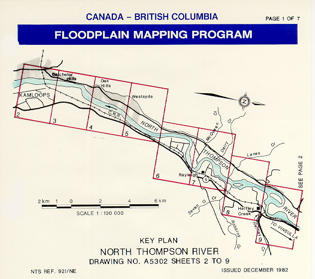
- North Thompson River Floodplain Mapsheet Key Plan 1 of 7
(gif/118.8 Kb)
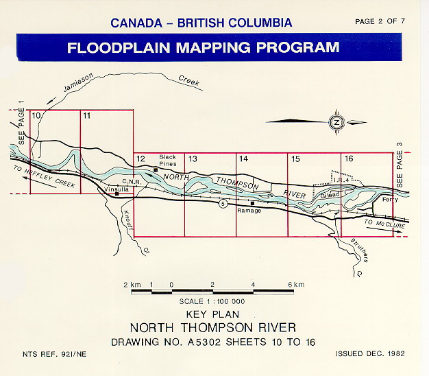
- North Thompson River Floodplain Mapsheet Key Plan 2 of 7
(gif/103.6 Kb)
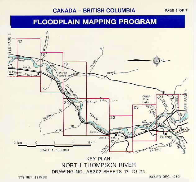
- North Thompson River Floodplain Mapsheet Key Plan 3 of 7
(gif/122.3 Kb)
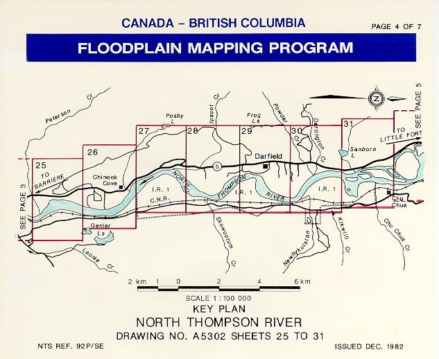
- North Thompson River Floodplain Mapsheet Key Plan 4 of 7
(gif/117.8 Kb)
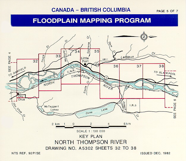
- North Thompson River Floodplain Mapsheet Key Plan 5 of 7
(gif/118.7 Kb)
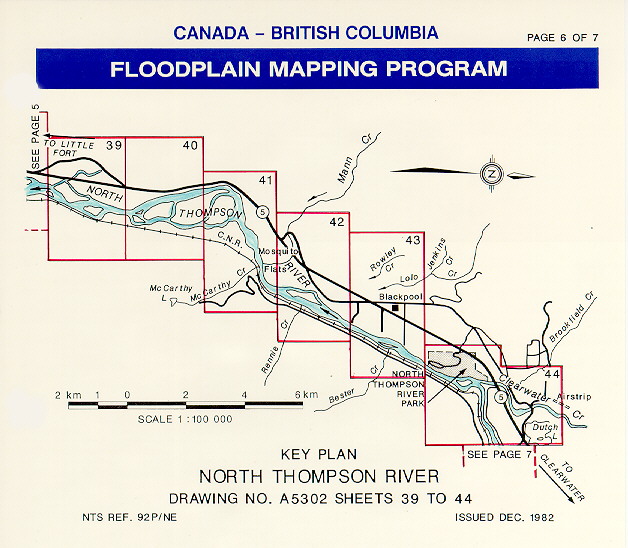
- North Thompson River Floodplain Mapsheet Key Plan 6 of 7
(gif/115.5 Kb)
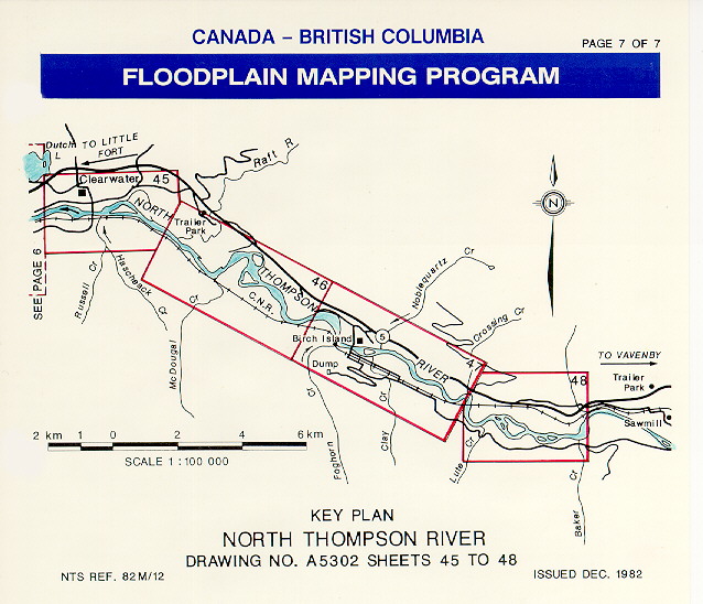
- North Thompson River Floodplain Mapsheet Key Plan 7 of 7
(gif/116.1 Kb)
- Thompson & North Thompson Rivers (Kamloops Area) Floodplain Mapsheet 5112-16
(pdf/17.3 Mb)
- Thompson & North Thompson Rivers (Kamloops Area) Floodplain Mapsheet 5112-17
(pdf/23.5 Mb)
- Thompson & North Thompson Rivers (Kamloops Area) Floodplain Mapsheet 5112-18
(pdf/22.3 Mb)
- Thompson & North Thompson Rivers (Kamloops Area) Floodplain Mapsheet 5112-19
(pdf/16 Mb)
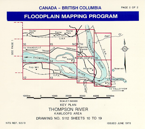
- Thompson & North Thompson Rivers (Kamloops Area) Floodplain Mapsheet Key Plan 2 of 2
(gif/115.8 Kb)
- XS Numbering Index and Profile Data (North Thompson 1971, 1978, 2000, 2001)
(pdf/81.4 Kb)
- XS Plan (Barriere 1983), copy of North Thompson Floodplain Mapsheet A5302-24
(pdf/6.3 Mb)
- XS Plan (Clearwater 1979), copy of North Thompson Floodplain Mapsheet A5302-44
(pdf/23 Mb)
- XS Plan (Feet) (North Thompson at Clearwater 1976)
(pdf/1.8 Mb)
- XS Plan (Metres) (North Thompson at Clearwater 1976)
(pdf/1.1 Mb)
- XS Plan (North Thompson 1971, 1978, 2000, 2001) Dwg 2001-1
XS 1.1 to XS 9.1
(pdf/2.5 Mb)
- XS Plan (North Thompson 1978, 2001) Dwg 2001-3
XS 9.2 to XS 20
(pdf/1.9 Mb)
- XS Plot (North Thompson 1978) (XS Not Rerun in 2000)
XS 4 (XS Not Rerun in 2000)
(pdf/137.6 Kb)
- XS Plots (North Thompson 1971) (XS Not Rerun in 2000)
XS's 1, 2, 3, 6 (XS Not Rerun in 2000)
(zip/491.4 Kb)
- XS Plots Single & Multiyear (North Thompson 1971, 1978, 2000) 1 of 8
XS 1.1 to XS 3.3
(zip/23 Mb)
- XS Plots Single & Multiyear (North Thompson 1971, 1978, 2000) 2 of 8
XS 3.4 to XS 5.2
(zip/20.2 Mb)
- XS Plots Single & Multiyear (North Thompson 1978, 2000) 3 of 8
XS 6 to XS 7.1
(zip/20.9 Mb)
- XS Plots Single & Multiyear (North Thompson 1978, 2001) 4 of 8
Xs Plots (PDF and DWG) 7.2, 7.3, 7.4, 8,8.1,9, and 9.1
(zip/14 Mb)
- XS Plots Single & Multiyear (North Thompson 1978, 2001) 5 of 8
XS 9.2 to XS 12
(zip/25.1 Mb)
- XS Plots Single & Multiyear (North Thompson 1978, 2001) 6 of 8
XS 12.1 to XS 14.1
(zip/29.1 Mb)
- XS Plots Single & Multiyear (North Thompson 1978, 2001) 7 of 8
XS 15 to XS 17.2 (PDF and DWG)
(zip/10.2 Mb)
- XS Plots Single & Multiyear (North Thompson 1978, 2001) 8 of 8
XS 18 to XS 20
(zip/24.3 Mb)
- XS Thalweg & Water Level Profile Plot (North Thompson 1971, 1978, 2000, 2001)
XS 1.1 to XS 20
(pdf/178.5 Kb)
- XS Water Levels (North Thompson at Clearwater 1976)
(pdf/529 Kb)
|
| |
| Video Files
|
-
No files of this type available
|
| |
|
All Documents
|
|
|
| Contact
|
|
-
If you have any questions on the information presented, or require additional report data or attachments, please contact the Report Contact
|
|
|
North Thompson River (Kamloops to Vavenby) Floodplain Mapping (including Barriere and Clearwater Rivers) and BC Water Surveys Data
|
Author: BC Water Surveys Unit and Canada-BC Floodplain Mapping Program
|
Old Reference Number: Project # 73-81
|
Old Reference System: MoELP Water Surveys and Draughting Section
|
Date Published: Dec 1982
|
Report ID: 1891
|
Audience: Government and Public
|
Designated Floodplain Mapsheets
Channel Survey data including:
-Cross section and road profiles,
-HEC2 GR data files,
-Bridge Sketches,
-Plans showing location of cross sections,
-Coordinate files
|
Report Type
Subject
| |
Water Information - Floodplain Mapping Program |
| |
|
|
|
|
Warranty Disclaimer
This information is provided as a public service by the Government of British Columbia, Box 9411, Victoria, British Columbia, Canada V8W 9V1.
This Web site and all of the information it contains are provided "as is" without warranty of any kind, whether express or implied. All implied warranties, including, without limitation, implied warranties of merchantability, fitness for a particular purpose, and non-infringement, are hereby expressly disclaimed.
Limitation of Liabilities
Under no circumstances will the Government of British Columbia be liable to any person or business entity for any direct, indirect, special, incidental, consequential, or other damages based on any use of this Web site or any other Web site to which this site is linked, including, without limitation, any lost profits, business interruption, or loss of programs or information, even if the Government of British Columbia has been specifically advised of the possibility of such damages.
|
